


ps favori maurette, littoral et étangs

psester
User
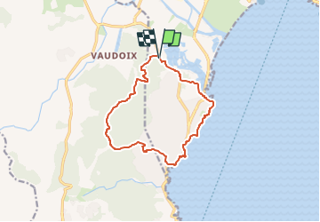

Length
13.1 km

Max alt
247 m

Uphill gradient
328 m
Km-Effort
17.5 km

Min alt
-1 m

Downhill gradient
333 m
Boucle
Yes
Creation date :
2024-04-12 07:24:39.341
Updated on :
2024-04-12 17:55:48.55
3h58
Difficulty : Difficult

FREE GPS app for hiking
 SityTrail
IGN / Geographical institutes
SityTrail Plus
The world is yours!
About
Trail Walking of 13.1 km to be discovered at Provence-Alpes-Côte d'Azur, Var, Fréjus. This trail is proposed by psester.
Positioning
Country:
France
Region :
Provence-Alpes-Côte d'Azur
Department/Province :
Var
Municipality :
Fréjus
Location:
Unknown
Start:(Dec)
Start:(UTM)
314656 ; 4808152 (32T) N.
Comments