


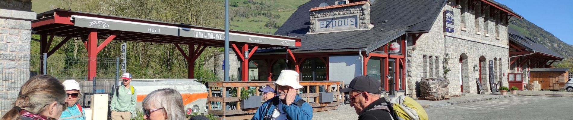
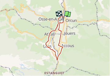
BEDOUS les chemins du gaves G4 "4014081"

marmotte65
User GUIDE


2h55
Difficulty : Easy

FREE GPS app for hiking
 SityTrail
IGN / Geographical institutes
SityTrail Plus
The world is yours!
About
Trail On foot of 11.2 km to be discovered at New Aquitaine, Pyrénées-Atlantiques, Bedous. This trail is proposed by marmotte65.
Description
Opter pour un départ de la gare de Bedous. Si vous venez en train, vous êtes prêt a partir.
Du goudron raisonnablement de superbe points de vue, et un denivellé facilement aval" sur les 11 km du parcours a refaire
Photos
 "
data-pinterest-text="Pin it"
data-tweet-text="share on twitter"
data-facebook-share-url="https://www.sitytrail.com/en/trails/4014081-bedous--bedous-les-chemins-du-gaves-g4--x4014081x/?photo=1#lg=1&slide=1"
data-twitter-share-url="https://www.sitytrail.com/en/trails/4014081-bedous--bedous-les-chemins-du-gaves-g4--x4014081x/?photo=1#lg=1&slide=1"
data-googleplus-share-url="https://www.sitytrail.com/en/trails/4014081-bedous--bedous-les-chemins-du-gaves-g4--x4014081x/?photo=1#lg=1&slide=1"
data-pinterest-share-url="https://www.sitytrail.com/en/trails/4014081-bedous--bedous-les-chemins-du-gaves-g4--x4014081x/?photo=1#lg=1&slide=1">
"
data-pinterest-text="Pin it"
data-tweet-text="share on twitter"
data-facebook-share-url="https://www.sitytrail.com/en/trails/4014081-bedous--bedous-les-chemins-du-gaves-g4--x4014081x/?photo=1#lg=1&slide=1"
data-twitter-share-url="https://www.sitytrail.com/en/trails/4014081-bedous--bedous-les-chemins-du-gaves-g4--x4014081x/?photo=1#lg=1&slide=1"
data-googleplus-share-url="https://www.sitytrail.com/en/trails/4014081-bedous--bedous-les-chemins-du-gaves-g4--x4014081x/?photo=1#lg=1&slide=1"
data-pinterest-share-url="https://www.sitytrail.com/en/trails/4014081-bedous--bedous-les-chemins-du-gaves-g4--x4014081x/?photo=1#lg=1&slide=1">
 "
data-pinterest-text="Pin it"
data-tweet-text="share on twitter"
data-facebook-share-url="https://www.sitytrail.com/en/trails/4014081-bedous--bedous-les-chemins-du-gaves-g4--x4014081x/?photo=2#lg=1&slide=2"
data-twitter-share-url="https://www.sitytrail.com/en/trails/4014081-bedous--bedous-les-chemins-du-gaves-g4--x4014081x/?photo=2#lg=1&slide=2"
data-googleplus-share-url="https://www.sitytrail.com/en/trails/4014081-bedous--bedous-les-chemins-du-gaves-g4--x4014081x/?photo=2#lg=1&slide=2"
data-pinterest-share-url="https://www.sitytrail.com/en/trails/4014081-bedous--bedous-les-chemins-du-gaves-g4--x4014081x/?photo=2#lg=1&slide=2">
"
data-pinterest-text="Pin it"
data-tweet-text="share on twitter"
data-facebook-share-url="https://www.sitytrail.com/en/trails/4014081-bedous--bedous-les-chemins-du-gaves-g4--x4014081x/?photo=2#lg=1&slide=2"
data-twitter-share-url="https://www.sitytrail.com/en/trails/4014081-bedous--bedous-les-chemins-du-gaves-g4--x4014081x/?photo=2#lg=1&slide=2"
data-googleplus-share-url="https://www.sitytrail.com/en/trails/4014081-bedous--bedous-les-chemins-du-gaves-g4--x4014081x/?photo=2#lg=1&slide=2"
data-pinterest-share-url="https://www.sitytrail.com/en/trails/4014081-bedous--bedous-les-chemins-du-gaves-g4--x4014081x/?photo=2#lg=1&slide=2">
 "
data-pinterest-text="Pin it"
data-tweet-text="share on twitter"
data-facebook-share-url="https://www.sitytrail.com/en/trails/4014081-bedous--bedous-les-chemins-du-gaves-g4--x4014081x/?photo=3#lg=1&slide=3"
data-twitter-share-url="https://www.sitytrail.com/en/trails/4014081-bedous--bedous-les-chemins-du-gaves-g4--x4014081x/?photo=3#lg=1&slide=3"
data-googleplus-share-url="https://www.sitytrail.com/en/trails/4014081-bedous--bedous-les-chemins-du-gaves-g4--x4014081x/?photo=3#lg=1&slide=3"
data-pinterest-share-url="https://www.sitytrail.com/en/trails/4014081-bedous--bedous-les-chemins-du-gaves-g4--x4014081x/?photo=3#lg=1&slide=3">
"
data-pinterest-text="Pin it"
data-tweet-text="share on twitter"
data-facebook-share-url="https://www.sitytrail.com/en/trails/4014081-bedous--bedous-les-chemins-du-gaves-g4--x4014081x/?photo=3#lg=1&slide=3"
data-twitter-share-url="https://www.sitytrail.com/en/trails/4014081-bedous--bedous-les-chemins-du-gaves-g4--x4014081x/?photo=3#lg=1&slide=3"
data-googleplus-share-url="https://www.sitytrail.com/en/trails/4014081-bedous--bedous-les-chemins-du-gaves-g4--x4014081x/?photo=3#lg=1&slide=3"
data-pinterest-share-url="https://www.sitytrail.com/en/trails/4014081-bedous--bedous-les-chemins-du-gaves-g4--x4014081x/?photo=3#lg=1&slide=3">
 "
data-pinterest-text="Pin it"
data-tweet-text="share on twitter"
data-facebook-share-url="https://www.sitytrail.com/en/trails/4014081-bedous--bedous-les-chemins-du-gaves-g4--x4014081x/?photo=4#lg=1&slide=4"
data-twitter-share-url="https://www.sitytrail.com/en/trails/4014081-bedous--bedous-les-chemins-du-gaves-g4--x4014081x/?photo=4#lg=1&slide=4"
data-googleplus-share-url="https://www.sitytrail.com/en/trails/4014081-bedous--bedous-les-chemins-du-gaves-g4--x4014081x/?photo=4#lg=1&slide=4"
data-pinterest-share-url="https://www.sitytrail.com/en/trails/4014081-bedous--bedous-les-chemins-du-gaves-g4--x4014081x/?photo=4#lg=1&slide=4">
"
data-pinterest-text="Pin it"
data-tweet-text="share on twitter"
data-facebook-share-url="https://www.sitytrail.com/en/trails/4014081-bedous--bedous-les-chemins-du-gaves-g4--x4014081x/?photo=4#lg=1&slide=4"
data-twitter-share-url="https://www.sitytrail.com/en/trails/4014081-bedous--bedous-les-chemins-du-gaves-g4--x4014081x/?photo=4#lg=1&slide=4"
data-googleplus-share-url="https://www.sitytrail.com/en/trails/4014081-bedous--bedous-les-chemins-du-gaves-g4--x4014081x/?photo=4#lg=1&slide=4"
data-pinterest-share-url="https://www.sitytrail.com/en/trails/4014081-bedous--bedous-les-chemins-du-gaves-g4--x4014081x/?photo=4#lg=1&slide=4">
 "
data-pinterest-text="Pin it"
data-tweet-text="share on twitter"
data-facebook-share-url="https://www.sitytrail.com/en/trails/4014081-bedous--bedous-les-chemins-du-gaves-g4--x4014081x/?photo=5#lg=1&slide=5"
data-twitter-share-url="https://www.sitytrail.com/en/trails/4014081-bedous--bedous-les-chemins-du-gaves-g4--x4014081x/?photo=5#lg=1&slide=5"
data-googleplus-share-url="https://www.sitytrail.com/en/trails/4014081-bedous--bedous-les-chemins-du-gaves-g4--x4014081x/?photo=5#lg=1&slide=5"
data-pinterest-share-url="https://www.sitytrail.com/en/trails/4014081-bedous--bedous-les-chemins-du-gaves-g4--x4014081x/?photo=5#lg=1&slide=5">
"
data-pinterest-text="Pin it"
data-tweet-text="share on twitter"
data-facebook-share-url="https://www.sitytrail.com/en/trails/4014081-bedous--bedous-les-chemins-du-gaves-g4--x4014081x/?photo=5#lg=1&slide=5"
data-twitter-share-url="https://www.sitytrail.com/en/trails/4014081-bedous--bedous-les-chemins-du-gaves-g4--x4014081x/?photo=5#lg=1&slide=5"
data-googleplus-share-url="https://www.sitytrail.com/en/trails/4014081-bedous--bedous-les-chemins-du-gaves-g4--x4014081x/?photo=5#lg=1&slide=5"
data-pinterest-share-url="https://www.sitytrail.com/en/trails/4014081-bedous--bedous-les-chemins-du-gaves-g4--x4014081x/?photo=5#lg=1&slide=5">
 "
data-pinterest-text="Pin it"
data-tweet-text="share on twitter"
data-facebook-share-url="https://www.sitytrail.com/en/trails/4014081-bedous--bedous-les-chemins-du-gaves-g4--x4014081x/?photo=6#lg=1&slide=6"
data-twitter-share-url="https://www.sitytrail.com/en/trails/4014081-bedous--bedous-les-chemins-du-gaves-g4--x4014081x/?photo=6#lg=1&slide=6"
data-googleplus-share-url="https://www.sitytrail.com/en/trails/4014081-bedous--bedous-les-chemins-du-gaves-g4--x4014081x/?photo=6#lg=1&slide=6"
data-pinterest-share-url="https://www.sitytrail.com/en/trails/4014081-bedous--bedous-les-chemins-du-gaves-g4--x4014081x/?photo=6#lg=1&slide=6">
"
data-pinterest-text="Pin it"
data-tweet-text="share on twitter"
data-facebook-share-url="https://www.sitytrail.com/en/trails/4014081-bedous--bedous-les-chemins-du-gaves-g4--x4014081x/?photo=6#lg=1&slide=6"
data-twitter-share-url="https://www.sitytrail.com/en/trails/4014081-bedous--bedous-les-chemins-du-gaves-g4--x4014081x/?photo=6#lg=1&slide=6"
data-googleplus-share-url="https://www.sitytrail.com/en/trails/4014081-bedous--bedous-les-chemins-du-gaves-g4--x4014081x/?photo=6#lg=1&slide=6"
data-pinterest-share-url="https://www.sitytrail.com/en/trails/4014081-bedous--bedous-les-chemins-du-gaves-g4--x4014081x/?photo=6#lg=1&slide=6">
 "
data-pinterest-text="Pin it"
data-tweet-text="share on twitter"
data-facebook-share-url="https://www.sitytrail.com/en/trails/4014081-bedous--bedous-les-chemins-du-gaves-g4--x4014081x/?photo=7#lg=1&slide=7"
data-twitter-share-url="https://www.sitytrail.com/en/trails/4014081-bedous--bedous-les-chemins-du-gaves-g4--x4014081x/?photo=7#lg=1&slide=7"
data-googleplus-share-url="https://www.sitytrail.com/en/trails/4014081-bedous--bedous-les-chemins-du-gaves-g4--x4014081x/?photo=7#lg=1&slide=7"
data-pinterest-share-url="https://www.sitytrail.com/en/trails/4014081-bedous--bedous-les-chemins-du-gaves-g4--x4014081x/?photo=7#lg=1&slide=7">
"
data-pinterest-text="Pin it"
data-tweet-text="share on twitter"
data-facebook-share-url="https://www.sitytrail.com/en/trails/4014081-bedous--bedous-les-chemins-du-gaves-g4--x4014081x/?photo=7#lg=1&slide=7"
data-twitter-share-url="https://www.sitytrail.com/en/trails/4014081-bedous--bedous-les-chemins-du-gaves-g4--x4014081x/?photo=7#lg=1&slide=7"
data-googleplus-share-url="https://www.sitytrail.com/en/trails/4014081-bedous--bedous-les-chemins-du-gaves-g4--x4014081x/?photo=7#lg=1&slide=7"
data-pinterest-share-url="https://www.sitytrail.com/en/trails/4014081-bedous--bedous-les-chemins-du-gaves-g4--x4014081x/?photo=7#lg=1&slide=7">
 "
data-pinterest-text="Pin it"
data-tweet-text="share on twitter"
data-facebook-share-url="https://www.sitytrail.com/en/trails/4014081-bedous--bedous-les-chemins-du-gaves-g4--x4014081x/?photo=8#lg=1&slide=8"
data-twitter-share-url="https://www.sitytrail.com/en/trails/4014081-bedous--bedous-les-chemins-du-gaves-g4--x4014081x/?photo=8#lg=1&slide=8"
data-googleplus-share-url="https://www.sitytrail.com/en/trails/4014081-bedous--bedous-les-chemins-du-gaves-g4--x4014081x/?photo=8#lg=1&slide=8"
data-pinterest-share-url="https://www.sitytrail.com/en/trails/4014081-bedous--bedous-les-chemins-du-gaves-g4--x4014081x/?photo=8#lg=1&slide=8">
"
data-pinterest-text="Pin it"
data-tweet-text="share on twitter"
data-facebook-share-url="https://www.sitytrail.com/en/trails/4014081-bedous--bedous-les-chemins-du-gaves-g4--x4014081x/?photo=8#lg=1&slide=8"
data-twitter-share-url="https://www.sitytrail.com/en/trails/4014081-bedous--bedous-les-chemins-du-gaves-g4--x4014081x/?photo=8#lg=1&slide=8"
data-googleplus-share-url="https://www.sitytrail.com/en/trails/4014081-bedous--bedous-les-chemins-du-gaves-g4--x4014081x/?photo=8#lg=1&slide=8"
data-pinterest-share-url="https://www.sitytrail.com/en/trails/4014081-bedous--bedous-les-chemins-du-gaves-g4--x4014081x/?photo=8#lg=1&slide=8">
 "
data-pinterest-text="Pin it"
data-tweet-text="share on twitter"
data-facebook-share-url="https://www.sitytrail.com/en/trails/4014081-bedous--bedous-les-chemins-du-gaves-g4--x4014081x/?photo=9#lg=1&slide=9"
data-twitter-share-url="https://www.sitytrail.com/en/trails/4014081-bedous--bedous-les-chemins-du-gaves-g4--x4014081x/?photo=9#lg=1&slide=9"
data-googleplus-share-url="https://www.sitytrail.com/en/trails/4014081-bedous--bedous-les-chemins-du-gaves-g4--x4014081x/?photo=9#lg=1&slide=9"
data-pinterest-share-url="https://www.sitytrail.com/en/trails/4014081-bedous--bedous-les-chemins-du-gaves-g4--x4014081x/?photo=9#lg=1&slide=9">
"
data-pinterest-text="Pin it"
data-tweet-text="share on twitter"
data-facebook-share-url="https://www.sitytrail.com/en/trails/4014081-bedous--bedous-les-chemins-du-gaves-g4--x4014081x/?photo=9#lg=1&slide=9"
data-twitter-share-url="https://www.sitytrail.com/en/trails/4014081-bedous--bedous-les-chemins-du-gaves-g4--x4014081x/?photo=9#lg=1&slide=9"
data-googleplus-share-url="https://www.sitytrail.com/en/trails/4014081-bedous--bedous-les-chemins-du-gaves-g4--x4014081x/?photo=9#lg=1&slide=9"
data-pinterest-share-url="https://www.sitytrail.com/en/trails/4014081-bedous--bedous-les-chemins-du-gaves-g4--x4014081x/?photo=9#lg=1&slide=9">

Positioning
Comments