


bellevue

CABERMAT
User
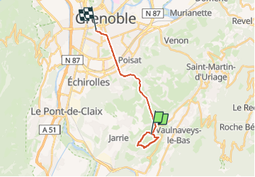

Length
15.3 km

Max alt
738 m

Uphill gradient
288 m
Km-Effort
20 km

Min alt
209 m

Downhill gradient
580 m
Boucle
No
Creation date :
2024-04-14 08:17:47.593
Updated on :
2024-04-14 11:24:16.444
3h06
Difficulty : Very difficult

FREE GPS app for hiking
 SityTrail
IGN / Geographical institutes
SityTrail Plus
The world is yours!
About
Trail Walking of 15.3 km to be discovered at Auvergne-Rhône-Alpes, Isère, Brié-et-Angonnes. This trail is proposed by CABERMAT.
Positioning
Country:
France
Region :
Auvergne-Rhône-Alpes
Department/Province :
Isère
Municipality :
Brié-et-Angonnes
Location:
Unknown
Start:(Dec)
Start:(UTM)
718737 ; 4998692 (31T) N.
Comments