


ST OFFENGE LES CHAVONNES

papou73
User
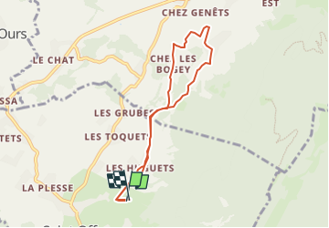

Length
7.1 km

Max alt
719 m

Uphill gradient
182 m
Km-Effort
9.5 km

Min alt
597 m

Downhill gradient
173 m
Boucle
Yes
Creation date :
2024-04-15 07:03:24.859
Updated on :
2024-04-15 07:04:02.314
2h09
Difficulty : Medium

FREE GPS app for hiking
 SityTrail
IGN / Geographical institutes
SityTrail Plus
The world is yours!
About
Trail Walking of 7.1 km to be discovered at Auvergne-Rhône-Alpes, Savoy, Saint-Offenge. This trail is proposed by papou73.
Positioning
Country:
France
Region :
Auvergne-Rhône-Alpes
Department/Province :
Savoy
Municipality :
Saint-Offenge
Location:
Saint-Offenge-Dessous
Start:(Dec)
Start:(UTM)
267641 ; 5068992 (32T) N.
Comments