


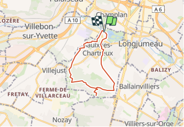
Saulx les Chartreux - les Rochers

Guy Laurent
User

Length
10.7 km

Max alt
167 m

Uphill gradient
181 m
Km-Effort
13.1 km

Min alt
43 m

Downhill gradient
181 m
Boucle
Yes
Creation date :
2024-04-15 09:14:48.448
Updated on :
2024-04-15 09:15:25.918
2h58
Difficulty : Difficult

FREE GPS app for hiking
 SityTrail
IGN / Geographical institutes
SityTrail Plus
The world is yours!
About
Trail Walking of 10.7 km to be discovered at Ile-de-France, Essonne, Saulx-les-Chartreux. This trail is proposed by Guy Laurent.
Positioning
Country:
France
Region :
Ile-de-France
Department/Province :
Essonne
Municipality :
Saulx-les-Chartreux
Location:
Unknown
Start:(Dec)
Start:(UTM)
446371 ; 5394300 (31U) N.
Comments