


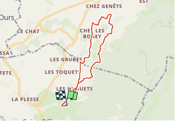
Saint-Offenge-Dessous Cusy

michel.pegaz
User

Length
7.4 km

Max alt
755 m

Uphill gradient
204 m
Km-Effort
10.1 km

Min alt
600 m

Downhill gradient
198 m
Boucle
Yes
Creation date :
2024-04-15 11:44:15.0
Updated on :
2024-04-18 08:57:43.842
2h18
Difficulty : Medium

FREE GPS app for hiking
 SityTrail
IGN / Geographical institutes
SityTrail Plus
The world is yours!
About
Trail Walking of 7.4 km to be discovered at Auvergne-Rhône-Alpes, Savoy, Saint-Offenge. This trail is proposed by michel.pegaz.
Description
Randonnée agréable entre Saint-Offenge-Dessous et Cusy
Un peu de route communale et sentier le long des pâturages et dans les bois de feuillus.
Photos


Positioning
Country:
France
Region :
Auvergne-Rhône-Alpes
Department/Province :
Savoy
Municipality :
Saint-Offenge
Location:
Saint-Offenge-Dessous
Start:(Dec)
Start:(UTM)
267593 ; 5069004 (32T) N.
Comments