


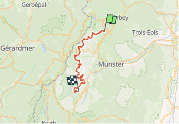
Jour 3 Orbey au Schnepfenried

Rémy Isenmann
User

Length
34 km

Max alt
1128 m

Uphill gradient
1338 m
Km-Effort
52 km

Min alt
494 m

Downhill gradient
1161 m
Boucle
No
Creation date :
2024-04-16 14:05:00.615
Updated on :
2024-04-16 14:07:42.718
0m
Difficulty : Very easy

FREE GPS app for hiking
 SityTrail
IGN / Geographical institutes
SityTrail Plus
The world is yours!
About
Trail Equestrian of 34 km to be discovered at Grand Est, Haut-Rhin, Orbey. This trail is proposed by Rémy Isenmann.
Positioning
Country:
France
Region :
Grand Est
Department/Province :
Haut-Rhin
Municipality :
Orbey
Location:
Unknown
Start:(Dec)
Start:(UTM)
359910 ; 5329365 (32U) N.
Comments