


Rando Blandy les Tours 10km RAT

jeanmarcMasson
User GUIDE
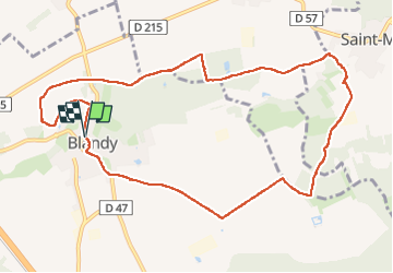

Length
10.7 km

Max alt
100 m

Uphill gradient
98 m
Km-Effort
12 km

Min alt
62 m

Downhill gradient
98 m
Boucle
Yes
Creation date :
2024-04-17 07:49:16.88
Updated on :
2024-04-17 10:23:27.99
2h21
Difficulty : Medium

FREE GPS app for hiking
 SityTrail
IGN / Geographical institutes
SityTrail Plus
The world is yours!
About
Trail Walking of 10.7 km to be discovered at Ile-de-France, Seine-et-Marne, Blandy. This trail is proposed by jeanmarcMasson.
Positioning
Country:
France
Region :
Ile-de-France
Department/Province :
Seine-et-Marne
Municipality :
Blandy
Location:
Unknown
Start:(Dec)
Start:(UTM)
483877 ; 5379459 (31U) N.
Comments