


1 Condom

thonyc
User GUIDE
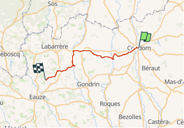

Length
31 km

Max alt
180 m

Uphill gradient
474 m
Km-Effort
37 km

Min alt
72 m

Downhill gradient
423 m
Boucle
No
Creation date :
2024-04-16 06:30:08.893
Updated on :
2024-04-17 14:44:17.752
8h57
Difficulty : Difficult

FREE GPS app for hiking
 SityTrail
IGN / Geographical institutes
SityTrail Plus
The world is yours!
About
Trail Walking of 31 km to be discovered at Occitania, Gers, Condom. This trail is proposed by thonyc.
Positioning
Country:
France
Region :
Occitania
Department/Province :
Gers
Municipality :
Condom
Location:
Unknown
Start:(Dec)
Start:(UTM)
289211 ; 4870289 (31T) N.
Comments