


2 eauze

thonyc
User GUIDE
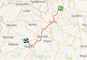

Length
27 km

Max alt
180 m

Uphill gradient
393 m
Km-Effort
32 km

Min alt
94 m

Downhill gradient
438 m
Boucle
No
Creation date :
2024-04-17 06:39:28.977
Updated on :
2024-04-17 14:44:20.617
8h03
Difficulty : Difficult

FREE GPS app for hiking
 SityTrail
IGN / Geographical institutes
SityTrail Plus
The world is yours!
About
Trail Walking of 27 km to be discovered at Occitania, Gers, Eauze. This trail is proposed by thonyc.
Positioning
Country:
France
Region :
Occitania
Department/Province :
Gers
Municipality :
Eauze
Location:
Unknown
Start:(Dec)
Start:(UTM)
269158 ; 4864128 (31T) N.
Comments