


Jalogny

janussity
User
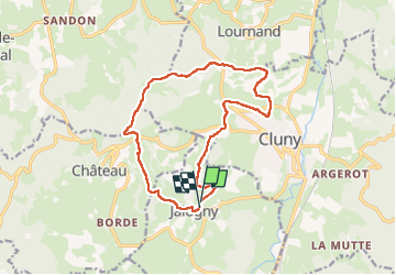

Length
14.2 km

Max alt
545 m

Uphill gradient
475 m
Km-Effort
21 km

Min alt
243 m

Downhill gradient
482 m
Boucle
Yes
Creation date :
2024-04-18 12:04:23.118
Updated on :
2024-04-18 14:56:25.762
2h46
Difficulty : Difficult

FREE GPS app for hiking
 SityTrail
IGN / Geographical institutes
SityTrail Plus
The world is yours!
About
Trail Walking of 14.2 km to be discovered at Bourgogne-Franche-Comté, Saône-et-Loire, Jalogny. This trail is proposed by janussity.
Description
Belle rando.temps ftais
Positioning
Country:
France
Region :
Bourgogne-Franche-Comté
Department/Province :
Saône-et-Loire
Municipality :
Jalogny
Location:
Unknown
Start:(Dec)
Start:(UTM)
625457 ; 5142037 (31T) N.
Comments