


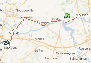
J18_Moissac - Auvillar - Bardigues

MAD-CVW
User


7h32
Difficulty : Very difficult

FREE GPS app for hiking
 SityTrail
IGN / Geographical institutes
SityTrail Plus
The world is yours!
About
Trail Walking of 29 km to be discovered at Occitania, Tarn-et-Garonne, Boudou. This trail is proposed by MAD-CVW.
Description
Au départ de Moissac, le GR65 suit les sentiers des collines. Possibilité de faire du plat par variante le long du canal latéral de la Garonne jusqu'à Commevic. (Dénivelé 320 et -237 au lieu de 555 et -463).
Néanmoins, le long du canal, c'est de la piste cyclable asphaltée pas toujours agréable.
Positioning
Comments