


Condorcet

raygautier
User
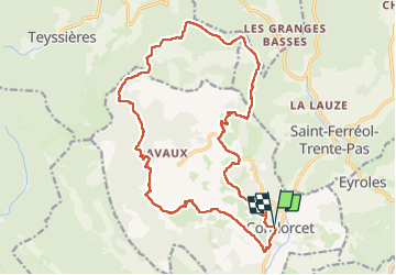

Length
21 km

Max alt
863 m

Uphill gradient
755 m
Km-Effort
31 km

Min alt
340 m

Downhill gradient
767 m
Boucle
Yes
Creation date :
2024-04-18 07:08:40.0
Updated on :
2024-04-21 04:28:03.572

FREE GPS app for hiking
 SityTrail
IGN / Geographical institutes
SityTrail Plus
The world is yours!
About
Trail of 21 km to be discovered at Auvergne-Rhône-Alpes, Drôme, Condorcet. This trail is proposed by raygautier.
Positioning
Country:
France
Region :
Auvergne-Rhône-Alpes
Department/Province :
Drôme
Municipality :
Condorcet
Location:
Unknown
Start:(Dec)
Start:(UTM)
675059 ; 4919468 (31T) N.
Comments