


Le pic de l'ours en boucle

CABERMAT
User
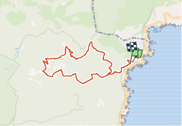

Length
9.2 km

Max alt
480 m

Uphill gradient
483 m
Km-Effort
15.6 km

Min alt
28 m

Downhill gradient
461 m
Boucle
No
Creation date :
2024-04-21 07:17:31.284
Updated on :
2024-04-21 12:41:01.532
5h23
Difficulty : Difficult

FREE GPS app for hiking
 SityTrail
IGN / Geographical institutes
SityTrail Plus
The world is yours!
About
Trail Walking of 9.2 km to be discovered at Provence-Alpes-Côte d'Azur, Var, Saint-Raphaël. This trail is proposed by CABERMAT.
Positioning
Country:
France
Region :
Provence-Alpes-Côte d'Azur
Department/Province :
Var
Municipality :
Saint-Raphaël
Location:
Unknown
Start:(Dec)
Start:(UTM)
332156 ; 4815655 (32T) N.
Comments