


La farlède-Tourris

FSantoni
User
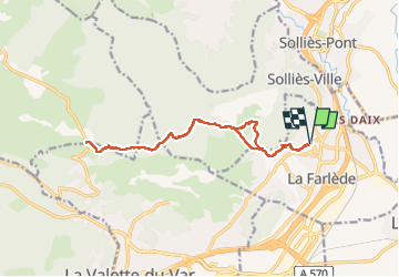

Length
16 km

Max alt
463 m

Uphill gradient
506 m
Km-Effort
23 km

Min alt
90 m

Downhill gradient
506 m
Boucle
Yes
Creation date :
2024-04-21 06:19:45.772
Updated on :
2024-04-21 18:28:03.656
6h36
Difficulty : Very difficult

FREE GPS app for hiking
 SityTrail
IGN / Geographical institutes
SityTrail Plus
The world is yours!
About
Trail Walking of 16 km to be discovered at Provence-Alpes-Côte d'Azur, Var, La Farlède. This trail is proposed by FSantoni.
Description
Des sentiers trés agréables sur les flancs du Coudon
Photos


Positioning
Country:
France
Region :
Provence-Alpes-Côte d'Azur
Department/Province :
Var
Municipality :
La Farlède
Location:
Unknown
Start:(Dec)
Start:(UTM)
259354 ; 4783710 (32T) N.
Comments