


6 pomps

thonyc
User GUIDE
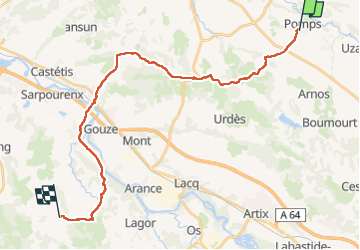

Length
27 km

Max alt
231 m

Uphill gradient
434 m
Km-Effort
33 km

Min alt
72 m

Downhill gradient
447 m
Boucle
No
Creation date :
2024-04-21 06:28:32.979
Updated on :
2024-04-21 14:17:14.192
7h47
Difficulty : Difficult

FREE GPS app for hiking
 SityTrail
IGN / Geographical institutes
SityTrail Plus
The world is yours!
About
Trail Walking of 27 km to be discovered at New Aquitaine, Pyrénées-Atlantiques, Pomps. This trail is proposed by thonyc.
Positioning
Country:
France
Region :
New Aquitaine
Department/Province :
Pyrénées-Atlantiques
Municipality :
Pomps
Location:
Unknown
Start:(Dec)
Start:(UTM)
698700 ; 4818060 (30T) N.
Comments