


2015-04-01 Rando Vaugrineuse

jchezlemas
User
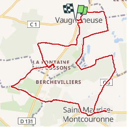

Length
13.5 km

Max alt
107 m

Uphill gradient
138 m
Km-Effort
15.3 km

Min alt
68 m

Downhill gradient
138 m
Boucle
Yes
Creation date :
2015-04-01 00:00:00.0
Updated on :
2015-04-01 00:00:00.0
3h23
Difficulty : Easy

FREE GPS app for hiking
 SityTrail
IGN / Geographical institutes
SityTrail Plus
The world is yours!
About
Trail Walking of 13.5 km to be discovered at Ile-de-France, Essonne, Vaugrigneuse. This trail is proposed by jchezlemas.
Positioning
Country:
France
Region :
Ile-de-France
Department/Province :
Essonne
Municipality :
Vaugrigneuse
Location:
Unknown
Start:(Dec)
Start:(UTM)
435107 ; 5383630 (31U) N.
Comments