


ANGIENS (SILERON-ICLON)

juanluco76
User
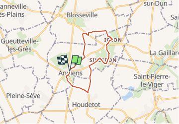

Length
9.9 km

Max alt
94 m

Uphill gradient
68 m
Km-Effort
10.8 km

Min alt
62 m

Downhill gradient
68 m
Boucle
Yes
Creation date :
2024-04-21 21:31:36.9
Updated on :
2024-04-21 21:33:46.584
2h27
Difficulty : Medium

FREE GPS app for hiking
 SityTrail
IGN / Geographical institutes
SityTrail Plus
The world is yours!
About
Trail Walking of 9.9 km to be discovered at Normandy, Seine-Maritime, Angiens. This trail is proposed by juanluco76.
Positioning
Country:
France
Region :
Normandy
Department/Province :
Seine-Maritime
Municipality :
Angiens
Location:
Unknown
Start:(Dec)
Start:(UTM)
341119 ; 5521918 (31U) N.
Comments