


aven Méline le Garn

brandy
User
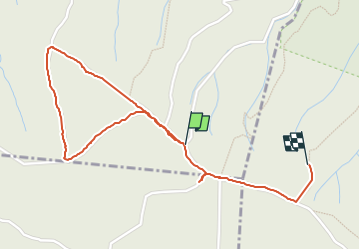

Length
2.2 km

Max alt
396 m

Uphill gradient
22 m
Km-Effort
2.5 km

Min alt
379 m

Downhill gradient
20 m
Boucle
No
Creation date :
2024-04-23 12:20:32.899
Updated on :
2024-04-23 13:40:43.756
58m
Difficulty : Easy

FREE GPS app for hiking
 SityTrail
IGN / Geographical institutes
SityTrail Plus
The world is yours!
About
Trail Walking of 2.2 km to be discovered at Auvergne-Rhône-Alpes, Ardèche, Labastide-de-Virac. This trail is proposed by brandy.
Photos

Positioning
Country:
France
Region :
Auvergne-Rhône-Alpes
Department/Province :
Ardèche
Municipality :
Labastide-de-Virac
Location:
Unknown
Start:(Dec)
Start:(UTM)
615535 ; 4910124 (31T) N.
Comments