


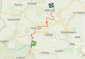
Jour 12 Climont au Champ du Feu

Rémy Isenmann
User

Length
17.5 km

Max alt
993 m

Uphill gradient
719 m
Km-Effort
26 km

Min alt
510 m

Downhill gradient
355 m
Boucle
No
Creation date :
2024-04-24 08:17:45.257
Updated on :
2024-04-24 08:20:00.329
0m
Difficulty : Very easy

FREE GPS app for hiking
 SityTrail
IGN / Geographical institutes
SityTrail Plus
The world is yours!
About
Trail Equestrian of 17.5 km to be discovered at Grand Est, Bas-Rhin, Urbeis. This trail is proposed by Rémy Isenmann.
Positioning
Country:
France
Region :
Grand Est
Department/Province :
Bas-Rhin
Municipality :
Urbeis
Location:
Unknown
Start:(Dec)
Start:(UTM)
365305 ; 5355017 (32U) N.
Comments