


havelange

Wernerch
User
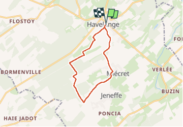

Length
10 km

Max alt
323 m

Uphill gradient
116 m
Km-Effort
11.5 km

Min alt
274 m

Downhill gradient
117 m
Boucle
Yes
Creation date :
2024-04-25 11:24:46.091
Updated on :
2024-04-25 13:51:04.682
2h26
Difficulty : Medium

FREE GPS app for hiking
 SityTrail
IGN / Geographical institutes
SityTrail Plus
The world is yours!
About
Trail Walking of 10 km to be discovered at Wallonia, Namur, Havelange. This trail is proposed by Wernerch.
Positioning
Country:
Belgium
Region :
Wallonia
Department/Province :
Namur
Municipality :
Havelange
Location:
Unknown
Start:(Dec)
Start:(UTM)
659331 ; 5584009 (31U) N.
Comments