


20150402 radepont

doudet
User
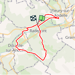

Length
15.4 km

Max alt
156 m

Uphill gradient
285 m
Km-Effort
19.2 km

Min alt
15 m

Downhill gradient
285 m
Boucle
Yes
Creation date :
2018-09-11 09:12:21.817
Updated on :
2018-09-11 09:12:21.817
4h08
Difficulty : Medium

FREE GPS app for hiking
 SityTrail
IGN / Geographical institutes
SityTrail Plus
The world is yours!
About
Trail Walking of 15.4 km to be discovered at Normandy, Eure, Radepont. This trail is proposed by doudet.
Description
Rando de Radepont Aller Retour de 15Km400 Temps Passable
Positioning
Country:
France
Region :
Normandy
Department/Province :
Eure
Municipality :
Radepont
Location:
Unknown
Start:(Dec)
Start:(UTM)
378368 ; 5468328 (31U) N.
Comments