


apremont mat G2

Nila81
User

Length
6.6 km

Max alt
379 m

Uphill gradient
171 m
Km-Effort
8.5 km

Min alt
246 m

Downhill gradient
63 m
Boucle
No
Creation date :
2024-04-26 16:31:12.639
Updated on :
2024-04-26 16:31:48.901
1h55
Difficulty : Medium

FREE GPS app for hiking
 SityTrail
IGN / Geographical institutes
SityTrail Plus
The world is yours!
About
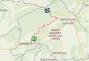
Trail Walking of 6.6 km to be discovered at Grand Est, Meuse, Apremont-la-Forêt. This trail is proposed by Nila81.
Positioning
Country:
France
Region :
Grand Est
Department/Province :
Meuse
Municipality :
Apremont-la-Forêt
Location:
Marbotte
Start:(Dec)
Start:(UTM)
689874 ; 5412219 (31U) N.
Comments