


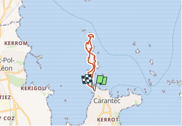
2024-04-27 tour ile Callot

jacq58
User

Length
8.8 km

Max alt
19 m

Uphill gradient
52 m
Km-Effort
9.5 km

Min alt
0 m

Downhill gradient
53 m
Boucle
Yes
Creation date :
2024-04-27 10:11:55.383
Updated on :
2024-04-28 15:33:39.154
2h16
Difficulty : Easy

FREE GPS app for hiking
 SityTrail
IGN / Geographical institutes
SityTrail Plus
The world is yours!
About
Trail Walking of 8.8 km to be discovered at Brittany, Finistère, Carantec. This trail is proposed by jacq58.
Photos


Positioning
Country:
France
Region :
Brittany
Department/Province :
Finistère
Municipality :
Carantec
Location:
Unknown
Start:(Dec)
Start:(UTM)
432070 ; 5391487 (30U) N.
Comments