


ITI0206

jeanic63
User
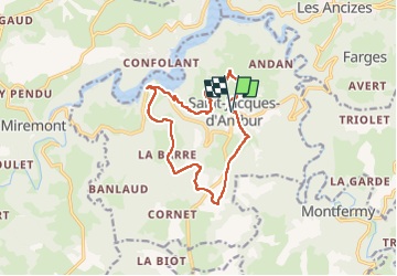

Length
12.8 km

Max alt
739 m

Uphill gradient
331 m
Km-Effort
17.2 km

Min alt
514 m

Downhill gradient
332 m
Boucle
Yes
Creation date :
2024-04-30 14:36:11.413
Updated on :
2024-04-30 14:42:06.494
3h54
Difficulty : Easy

FREE GPS app for hiking
 SityTrail
IGN / Geographical institutes
SityTrail Plus
The world is yours!
About
Trail On foot of 12.8 km to be discovered at Auvergne-Rhône-Alpes, Puy-de-Dôme. This trail is proposed by jeanic63.
Description
départ saint Jacques d'Ambur parking devant l'église
Positioning
Country:
France
Region :
Auvergne-Rhône-Alpes
Department/Province :
Puy-de-Dôme
Municipality :
Unknown
Location:
Unknown
Start:(Dec)
Start:(UTM)
482630 ; 5083214 (31T) N.
Comments
Belle randonnée à travers les forêts et les villages