


20240430-amfreville sur iton

doudet
User
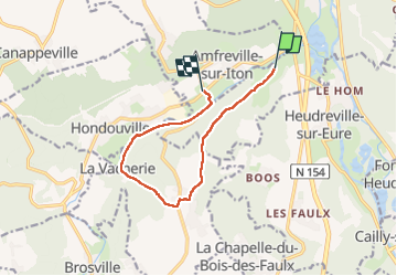

Length
9.2 km

Max alt
141 m

Uphill gradient
167 m
Km-Effort
11.5 km

Min alt
20 m

Downhill gradient
186 m
Boucle
No
Creation date :
2024-04-30 12:35:14.274
Updated on :
2024-05-05 06:14:21.359
2h38
Difficulty : Medium

FREE GPS app for hiking
 SityTrail
IGN / Geographical institutes
SityTrail Plus
The world is yours!
About
Trail Walking of 9.2 km to be discovered at Normandy, Eure, Acquigny. This trail is proposed by doudet.
Photos


26 photos in total. Please click on a photo to see them all in the gallery.
Positioning
Country:
France
Region :
Normandy
Department/Province :
Eure
Municipality :
Acquigny
Location:
Unknown
Start:(Dec)
Start:(UTM)
366712 ; 5445931 (31U) N.
Comments