


T-A53S- Forêt de Montmorency

Jack-94
User
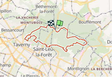

Length
16.3 km

Max alt
193 m

Uphill gradient
329 m
Km-Effort
21 km

Min alt
99 m

Downhill gradient
330 m
Boucle
Yes
Creation date :
2024-04-28 07:55:16.541
Updated on :
2024-05-01 07:20:46.402
6h50
Difficulty : Very difficult

FREE GPS app for hiking
 SityTrail
IGN / Geographical institutes
SityTrail Plus
The world is yours!
About
Trail Walking of 16.3 km to be discovered at Ile-de-France, Val-d'Oise, Saint-Prix. This trail is proposed by Jack-94.
Positioning
Country:
France
Region :
Ile-de-France
Department/Province :
Val-d'Oise
Municipality :
Saint-Prix
Location:
Unknown
Start:(Dec)
Start:(UTM)
446012 ; 5431857 (31U) N.
Comments