


Muguet_030524

d.rognon
User
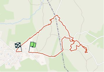

Length
2.9 km

Max alt
323 m

Uphill gradient
26 m
Km-Effort
3.3 km

Min alt
306 m

Downhill gradient
22 m
Boucle
Yes
Creation date :
2024-05-03 13:08:41.955
Updated on :
2024-05-03 14:58:55.762
1h49
Difficulty : Very easy

FREE GPS app for hiking
 SityTrail
IGN / Geographical institutes
SityTrail Plus
The world is yours!
About
Trail Walking of 2.9 km to be discovered at Auvergne-Rhône-Alpes, Rhône, Lentilly. This trail is proposed by d.rognon.
Description
recherche de muguet
Positioning
Country:
France
Region :
Auvergne-Rhône-Alpes
Department/Province :
Rhône
Municipality :
Lentilly
Location:
Unknown
Start:(Dec)
Start:(UTM)
631823 ; 5073160 (31T) N.
Comments