


111111

patign
User
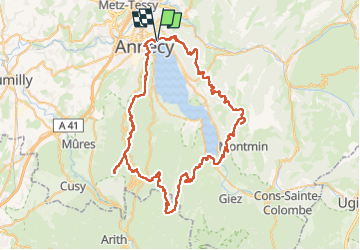

Length
89 km

Max alt
1694 m

Uphill gradient
4836 m
Km-Effort
153 km

Min alt
445 m

Downhill gradient
4837 m
Boucle
Yes
Creation date :
2024-05-04 10:31:54.913
Updated on :
2024-05-04 17:51:43.882
34h53
Difficulty : Very difficult

FREE GPS app for hiking
 SityTrail
IGN / Geographical institutes
SityTrail Plus
The world is yours!
About
Trail Walking of 89 km to be discovered at Auvergne-Rhône-Alpes, Upper Savoy, Annecy. This trail is proposed by patign.
Positioning
Country:
France
Region :
Auvergne-Rhône-Alpes
Department/Province :
Upper Savoy
Municipality :
Annecy
Location:
Annecy-le-Vieux
Start:(Dec)
Start:(UTM)
278733 ; 5087373 (32T) N.
Comments