Trail Walking Braud-et-Saint-Louis - terre d oiseaux - Photo
 phil331
phil331

User

© OpenStreetMap contributors
Length
Length
6.9 km
Max alt
Max alt
4 m
Uphill gradient
Uphill gradient
18 m
Km-Effort
Km-Effort  
7.1 km
Min alt
Min alt
-1 m
Downhill gradient
Downhill gradient
18 m
Boucle
Boucle
Yes
Creation date :
2015-04-05 00:00:00.0
Updated on :
2015-04-05 00:00:00.0

(0 Reviews)

Walking
Walking
2h54
Difficulty : Unknown

Scan this QR Code to open this trail in the SityTrail application

FREE GPS app for hiking

Logo SityTrail SityTrail

IGN / Geographical institutes

Download SityTrail from the App Store Download SityTrail from Google Play

Logo SityTrail SityTrail World

The world is yours!

Download SityTrail from the App Store Download SityTrail from Google Play Download SityTrail on Huawei AppGallery

About

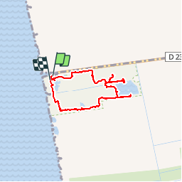
Trail Walking of 6.9 km to be discovered at New Aquitaine, Gironde, Braud-et-Saint-Louis. This trail is proposed by phil331.

Description

promenade ornithologique

Elevation profile

Photos

Positioning

Country:
France
Region :
New Aquitaine
Department/Province :
Gironde
Municipality :
Braud-et-Saint-Louis
Location:
Unknown
Start:(UTM)
680413 ; 5017122 (30T) N.

Trails nearby

Trail Walking Saint-Sorlin-de-Conac - Vitrezay  - Photo
Walking
nijo17

Walking

Medium
Saint-Sorlin-de-Conac, New Aquitaine, Charente-Maritime, France
10.8 km | 11.2 km-effort
2h 19min
Yes


Close
My subscriptions