


nant

ajasse
User
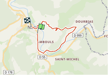

Length
6.2 km

Max alt
578 m

Uphill gradient
135 m
Km-Effort
7.9 km

Min alt
474 m

Downhill gradient
126 m
Boucle
No
Creation date :
2024-05-04 11:36:23.822
Updated on :
2024-05-04 13:57:35.776
1h53
Difficulty : Very easy

FREE GPS app for hiking
 SityTrail
IGN / Geographical institutes
SityTrail Plus
The world is yours!
About
Trail Walking of 6.2 km to be discovered at Occitania, Aveyron, Nant. This trail is proposed by ajasse.
Positioning
Country:
France
Region :
Occitania
Department/Province :
Aveyron
Municipality :
Nant
Location:
Unknown
Start:(Dec)
Start:(UTM)
524397 ; 4874140 (31T) N.
Comments