


T-A517-Vayres-sur-Essonne

Jack-94
User
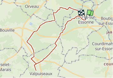

Length
17.7 km

Max alt
139 m

Uphill gradient
191 m
Km-Effort
20 km

Min alt
63 m

Downhill gradient
190 m
Boucle
Yes
Creation date :
2024-05-05 07:31:17.254
Updated on :
2024-05-05 20:25:48.141
5h25
Difficulty : Very difficult

FREE GPS app for hiking
 SityTrail
IGN / Geographical institutes
SityTrail Plus
The world is yours!
About
Trail Walking of 17.7 km to be discovered at Ile-de-France, Essonne, Vayres-sur-Essonne. This trail is proposed by Jack-94.
Positioning
Country:
France
Region :
Ile-de-France
Department/Province :
Essonne
Municipality :
Vayres-sur-Essonne
Location:
Unknown
Start:(Dec)
Start:(UTM)
452228 ; 5365199 (31U) N.
Comments