


Camelas

mvge
User

Length
149 km

Max alt
503 m

Uphill gradient
3004 m
Km-Effort
189 km

Min alt
-1 m

Downhill gradient
2857 m
Boucle
No
Creation date :
2024-04-23 07:41:27.683
Updated on :
2024-05-07 13:12:18.895
5h36
Difficulty : Medium

FREE GPS app for hiking
 SityTrail
IGN / Geographical institutes
SityTrail Plus
The world is yours!
About
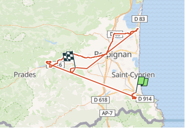
Trail Walking of 149 km to be discovered at Occitania, Pyrénées-Orientales, Argelès-sur-Mer. This trail is proposed by mvge.
Positioning
Country:
France
Region :
Occitania
Department/Province :
Pyrénées-Orientales
Municipality :
Argelès-sur-Mer
Location:
Unknown
Start:(Dec)
Start:(UTM)
501456 ; 4710305 (31T) N.
Comments