


pointe du Groin. ch des douaniers vers st malo

janussity
User
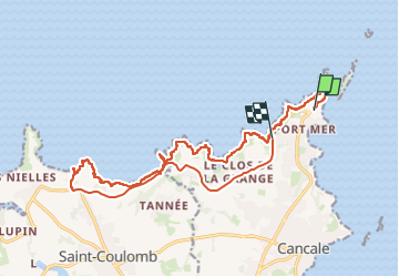

Length
18.5 km

Max alt
48 m

Uphill gradient
277 m
Km-Effort
22 km

Min alt
0 m

Downhill gradient
274 m
Boucle
No
Creation date :
2024-05-07 07:54:02.218
Updated on :
2024-05-07 14:59:17.454
3h31
Difficulty : Very difficult

FREE GPS app for hiking
 SityTrail
IGN / Geographical institutes
SityTrail Plus
The world is yours!
About
Trail Walking of 18.5 km to be discovered at Brittany, Ille-et-Vilaine, Cancale. This trail is proposed by janussity.
Description
journée ensoleillée
Positioning
Country:
France
Region :
Brittany
Department/Province :
Ille-et-Vilaine
Municipality :
Cancale
Location:
Unknown
Start:(Dec)
Start:(UTM)
584780 ; 5395364 (30U) N.
Comments