


Gluiras

raygautier
User
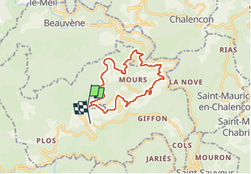

Length
14.5 km

Max alt
844 m

Uphill gradient
582 m
Km-Effort
22 km

Min alt
336 m

Downhill gradient
624 m
Boucle
No
Creation date :
2024-05-08 06:49:09.0
Updated on :
2024-05-08 12:18:27.376

FREE GPS app for hiking
 SityTrail
IGN / Geographical institutes
SityTrail Plus
The world is yours!
About
Trail of 14.5 km to be discovered at Auvergne-Rhône-Alpes, Ardèche, Gluiras. This trail is proposed by raygautier.
Positioning
Country:
France
Region :
Auvergne-Rhône-Alpes
Department/Province :
Ardèche
Municipality :
Gluiras
Location:
Unknown
Start:(Dec)
Start:(UTM)
620224 ; 4966999 (31T) N.
Comments