


Premièr jour

patign
User
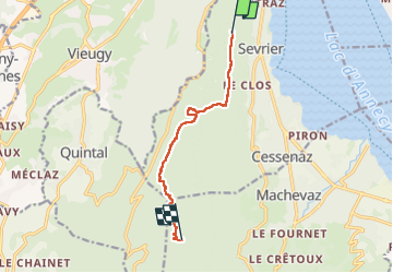

Length
8.5 km

Max alt
1383 m

Uphill gradient
676 m
Km-Effort
15.6 km

Min alt
770 m

Downhill gradient
96 m
Boucle
No
Creation date :
2024-05-08 13:20:00.0
Updated on :
2024-05-08 19:51:58.58
3h47
Difficulty : Difficult

FREE GPS app for hiking
 SityTrail
IGN / Geographical institutes
SityTrail Plus
The world is yours!
About
Trail Walking of 8.5 km to be discovered at Auvergne-Rhône-Alpes, Upper Savoy, Sevrier. This trail is proposed by patign.
Positioning
Country:
France
Region :
Auvergne-Rhône-Alpes
Department/Province :
Upper Savoy
Municipality :
Sevrier
Location:
Unknown
Start:(Dec)
Start:(UTM)
277346 ; 5083325 (32T) N.
Comments