


Le Rouet Vignes

Pascal-83
User
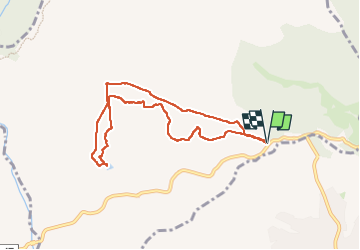

Length
8.2 km

Max alt
152 m

Uphill gradient
128 m
Km-Effort
9.9 km

Min alt
81 m

Downhill gradient
127 m
Boucle
Yes
Creation date :
2024-05-09 06:34:03.697
Updated on :
2024-05-09 09:26:57.265
2h52
Difficulty : Medium

FREE GPS app for hiking
 SityTrail
IGN / Geographical institutes
SityTrail Plus
The world is yours!
About
Trail Walking of 8.2 km to be discovered at Provence-Alpes-Côte d'Azur, Var, Le Muy. This trail is proposed by Pascal-83.
Description
marche simple 8km
Photos


Positioning
Country:
France
Region :
Provence-Alpes-Côte d'Azur
Department/Province :
Var
Municipality :
Le Muy
Location:
Unknown
Start:(Dec)
Start:(UTM)
308455 ; 4820832 (32T) N.
Comments