


Massilly circuit Annie

grasgilbert
User
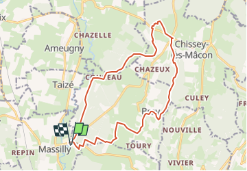

Length
17.5 km

Max alt
413 m

Uphill gradient
322 m
Km-Effort
22 km

Min alt
213 m

Downhill gradient
321 m
Boucle
Yes
Creation date :
2024-05-09 13:06:34.819
Updated on :
2024-05-09 13:10:55.305
4h57
Difficulty : Very difficult

FREE GPS app for hiking
 SityTrail
IGN / Geographical institutes
SityTrail Plus
The world is yours!
About
Trail Walking of 17.5 km to be discovered at Bourgogne-Franche-Comté, Saône-et-Loire, Massilly. This trail is proposed by grasgilbert.
Positioning
Country:
France
Region :
Bourgogne-Franche-Comté
Department/Province :
Saône-et-Loire
Municipality :
Massilly
Location:
Unknown
Start:(Dec)
Start:(UTM)
629025 ; 5150084 (31T) N.
Comments