


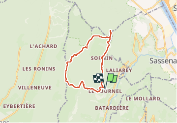
Engin / Fournel/ Dent du Loup) La Molière

okfred26
User

Length
12.7 km

Max alt
1644 m

Uphill gradient
766 m
Km-Effort
23 km

Min alt
928 m

Downhill gradient
768 m
Boucle
Yes
Creation date :
2024-05-09 07:18:05.704
Updated on :
2024-05-09 13:19:51.881
6h01
Difficulty : Medium

FREE GPS app for hiking
 SityTrail
IGN / Geographical institutes
SityTrail Plus
The world is yours!
About
Trail Walking of 12.7 km to be discovered at Auvergne-Rhône-Alpes, Isère, Engins. This trail is proposed by okfred26.
Positioning
Country:
France
Region :
Auvergne-Rhône-Alpes
Department/Province :
Isère
Municipality :
Engins
Location:
Unknown
Start:(Dec)
Start:(UTM)
705770 ; 5007660 (31T) N.
Comments