


Joanas

m.rozeron
User
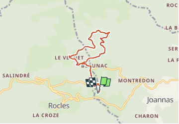

Length
6.9 km

Max alt
681 m

Uphill gradient
269 m
Km-Effort
10.5 km

Min alt
420 m

Downhill gradient
269 m
Boucle
Yes
Creation date :
2024-05-09 14:48:44.75
Updated on :
2024-05-09 16:21:34.602
1h32
Difficulty : Medium

FREE GPS app for hiking
 SityTrail
IGN / Geographical institutes
SityTrail Plus
The world is yours!
About
Trail Walking of 6.9 km to be discovered at Auvergne-Rhône-Alpes, Ardèche, Joannas. This trail is proposed by m.rozeron.
Positioning
Country:
France
Region :
Auvergne-Rhône-Alpes
Department/Province :
Ardèche
Municipality :
Joannas
Location:
Unknown
Start:(Dec)
Start:(UTM)
597702 ; 4935555 (31T) N.
Comments