


Jour 2

patign
User
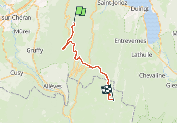

Length
21 km

Max alt
1694 m

Uphill gradient
863 m
Km-Effort
33 km

Min alt
898 m

Downhill gradient
1245 m
Boucle
No
Creation date :
2024-05-09 08:49:04.0
Updated on :
2024-05-09 19:36:26.027
9h48
Difficulty : Very difficult

FREE GPS app for hiking
 SityTrail
IGN / Geographical institutes
SityTrail Plus
The world is yours!
About
Trail Walking of 21 km to be discovered at Auvergne-Rhône-Alpes, Upper Savoy, Saint-Jorioz. This trail is proposed by patign.
Positioning
Country:
France
Region :
Auvergne-Rhône-Alpes
Department/Province :
Upper Savoy
Municipality :
Saint-Jorioz
Location:
Unknown
Start:(Dec)
Start:(UTM)
275531 ; 5077433 (32T) N.
Comments