


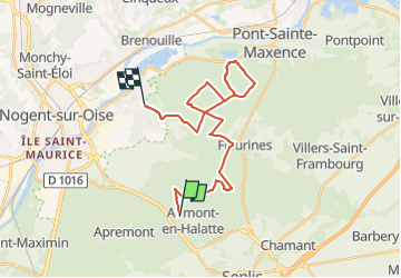
VTT Aumont - Verneuil

christianH
User

Length
24 km

Max alt
148 m

Uphill gradient
286 m
Km-Effort
28 km

Min alt
38 m

Downhill gradient
352 m
Boucle
No
Creation date :
2024-05-10 12:01:38.139
Updated on :
2024-05-10 12:02:19.625
1h57
Difficulty : Medium

FREE GPS app for hiking
 SityTrail
IGN / Geographical institutes
SityTrail Plus
The world is yours!
About
Trail Mountain bike of 24 km to be discovered at Hauts-de-France, Oise, Aumont-en-Halatte. This trail is proposed by christianH.
Positioning
Country:
France
Region :
Hauts-de-France
Department/Province :
Oise
Municipality :
Aumont-en-Halatte
Location:
Unknown
Start:(Dec)
Start:(UTM)
466970 ; 5453221 (31U) N.
Comments