


Pontaucault - Mont-Saint-Michel

jeanmarcMasson
User GUIDE
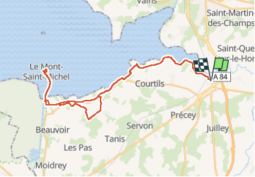

Length
39 km

Max alt
52 m

Uphill gradient
230 m
Km-Effort
42 km

Min alt
0 m

Downhill gradient
230 m
Boucle
Yes
Creation date :
2024-05-10 08:03:47.063
Updated on :
2024-05-10 15:40:21.009
4h14
Difficulty : Very difficult

FREE GPS app for hiking
 SityTrail
IGN / Geographical institutes
SityTrail Plus
The world is yours!
About
Trail Bicycle tourism of 39 km to be discovered at Normandy, Manche, Pontaubault. This trail is proposed by jeanmarcMasson.
Positioning
Country:
France
Region :
Normandy
Department/Province :
Manche
Municipality :
Pontaubault
Location:
Unknown
Start:(Dec)
Start:(UTM)
621539 ; 5387612 (30U) N.
Comments