


Jour 3

patign
User
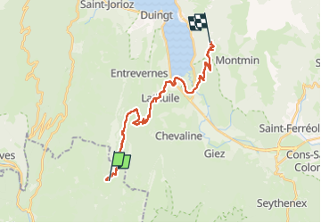

Length
25 km

Max alt
1388 m

Uphill gradient
1155 m
Km-Effort
40 km

Min alt
450 m

Downhill gradient
1038 m
Boucle
No
Creation date :
2024-05-10 07:55:44.0
Updated on :
2024-05-10 21:04:53.978
12h13
Difficulty : Very difficult

FREE GPS app for hiking
 SityTrail
IGN / Geographical institutes
SityTrail Plus
The world is yours!
About
Trail Walking of 25 km to be discovered at Auvergne-Rhône-Alpes, Savoy, Bellecombe-en-Bauges. This trail is proposed by patign.
Positioning
Country:
France
Region :
Auvergne-Rhône-Alpes
Department/Province :
Savoy
Municipality :
Bellecombe-en-Bauges
Location:
Unknown
Start:(Dec)
Start:(UTM)
279563 ; 5068836 (32T) N.
Comments