


cassis - les crêtes - vallon de la becasse

giovannoni
User
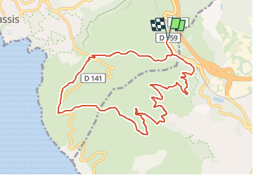

Length
11.5 km

Max alt
325 m

Uphill gradient
286 m
Km-Effort
15.3 km

Min alt
118 m

Downhill gradient
288 m
Boucle
Yes
Creation date :
2024-05-11 04:41:56.271
Updated on :
2024-05-11 04:41:56.162
3h28
Difficulty : Difficult

FREE GPS app for hiking
 SityTrail
IGN / Geographical institutes
SityTrail Plus
The world is yours!
About
Trail Walking of 11.5 km to be discovered at Provence-Alpes-Côte d'Azur, Bouches-du-Rhône, Cassis. This trail is proposed by giovannoni.
Positioning
Country:
France
Region :
Provence-Alpes-Côte d'Azur
Department/Province :
Bouches-du-Rhône
Municipality :
Cassis
Location:
Unknown
Start:(Dec)
Start:(UTM)
709545 ; 4787383 (31T) N.
Comments