


Lac de Meinettes de Cheminas

alinetpierre
User
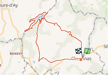

Length
13.5 km

Max alt
486 m

Uphill gradient
191 m
Km-Effort
16.1 km

Min alt
388 m

Downhill gradient
191 m
Boucle
Yes
Creation date :
2024-05-11 07:50:05.0
Updated on :
2024-05-11 12:37:44.867

FREE GPS app for hiking
 SityTrail
IGN / Geographical institutes
SityTrail Plus
The world is yours!
About
Trail of 13.5 km to be discovered at Auvergne-Rhône-Alpes, Ardèche, Cheminas. This trail is proposed by alinetpierre.
Description
Très beau tour de lac
Photos


Positioning
Country:
France
Region :
Auvergne-Rhône-Alpes
Department/Province :
Ardèche
Municipality :
Cheminas
Location:
Unknown
Start:(Dec)
Start:(UTM)
637844 ; 4998349 (31T) N.
Comments
Super