Trail Walking Oricourt - oricourt, oppenans,  aillevans  - Photo

oricourt, oppenans, aillevans

© OpenStreetMap contributors
Length
Length
7.7 km
Max alt
Max alt
397 m
Uphill gradient
Uphill gradient
180 m
Km-Effort
Km-Effort  
10.1 km
Min alt
Min alt
280 m
Downhill gradient
Downhill gradient
183 m
Boucle
Boucle
Yes
Creation date :
2024-05-11 09:43:21.37
Updated on :
2024-05-11 14:18:19.327

(0 Reviews)

Walking
Walking
4h34
Difficulty : Easy

Scan this QR Code to open this trail in the SityTrail application

FREE GPS app for hiking

Logo SityTrail SityTrail

IGN / Geographical institutes

Download SityTrail from the App Store Download SityTrail from Google Play

Logo SityTrail SityTrail World

The world is yours!

Download SityTrail from the App Store Download SityTrail from Google Play Download SityTrail on Huawei AppGallery

About

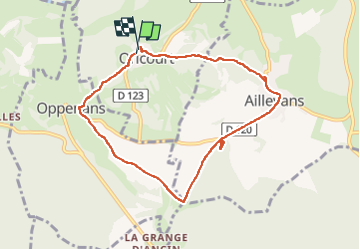
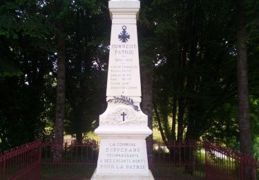
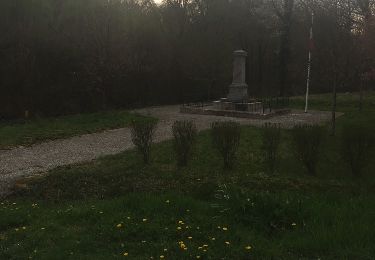
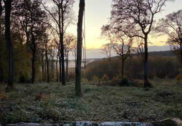
Trail Walking of 7.7 km to be discovered at Bourgogne-Franche-Comté, Haute-Saône, Oricourt. This trail is proposed by francislassauce.

Description

beaucoup trop de routes et chemins goudronnés

Elevation profile

Photos

Positioning

Country:
France
Region :
Bourgogne-Franche-Comté
Department/Province :
Haute-Saône
Municipality :
Oricourt
Location:
Unknown
Start:(UTM)
303959 ; 5274614 (32T) N.

Trails nearby

Trail Mountain bike Moimay - Oricourt et environs - Photo
Mountain bike
Raphaël K

Mountain bike

Very difficult
Moimay, Bourgogne-Franche-Comté, Haute-Saône, France
40 km | 49 km-effort
3h 0min
No
Trail Cycle Villersexel - Boucle des Monts de l'Ognon (Variante) - Villersexel  - Photo
Cycle
tracegps

Cycle

Difficult
Villersexel, Bourgogne-Franche-Comté, Haute-Saône, France
40 km | 47 km-effort
1h 49min
Yes
Trail Walking Oppenans - OPPENANS 70  - Photo
Walking
legios84

Walking

Medium
Oppenans, Bourgogne-Franche-Comté, Haute-Saône, France
24 km | 31 km-effort
7h 35min
Yes
Trail Walking Marast - Estrets-Vy les filain - Photo
Walking
dagobert5612

Walking

Very easy
Marast, Bourgogne-Franche-Comté, Haute-Saône, France
19.1 km | 23 km-effort
5h 50min
No
Trail 4x4 Villersexel - Mercredi 03 transversale  - Photo
4x4
eldingue

4x4

Villersexel, Bourgogne-Franche-Comté, Haute-Saône, France
153 km | 183 km-effort
6h 19min
No
Trail Walking Villersexel - monument des cosaques  - Photo
Walking
nicolasdresse

Walking

Easy
Villersexel, Bourgogne-Franche-Comté, Haute-Saône, France
8.2 km | 10 km-effort
2h 6min
Yes
Trail Walking Borey - Les baraques de borey- le creux qui sonne - bois de la brosse - Photo
Walking
nicolasdresse

Walking

Medium
Borey, Bourgogne-Franche-Comté, Haute-Saône, France
7.4 km | 9.1 km-effort
2h 12min
Yes
Trail Canoe - kayak Villersexel - Descente canoë villersexel-bonal - Photo
Canoe - kayak
nicolasdresse

Canoe - kayak

Easy
Villersexel, Bourgogne-Franche-Comté, Haute-Saône, France
11.5 km | 12.5 km-effort
3h 27min
No
Trail Walking Borey - Les patey - Photo
Walking
nicolasdresse

Walking

Medium
Borey, Bourgogne-Franche-Comté, Haute-Saône, France
5.3 km | 6.5 km-effort
1h 35min
Yes


Close
My subscriptions