


Jour 4

patign
User

Length
22 km

Max alt
1489 m

Uphill gradient
1165 m
Km-Effort
38 km

Min alt
587 m

Downhill gradient
1379 m
Boucle
No
Creation date :
2024-05-11 08:27:44.0
Updated on :
2024-05-11 19:23:56.978
9h43
Difficulty : Very difficult

FREE GPS app for hiking
 SityTrail
IGN / Geographical institutes
SityTrail Plus
The world is yours!
About
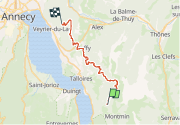
Trail Walking of 22 km to be discovered at Auvergne-Rhône-Alpes, Upper Savoy, Talloires-Montmin. This trail is proposed by patign.
Positioning
Country:
France
Region :
Auvergne-Rhône-Alpes
Department/Province :
Upper Savoy
Municipality :
Talloires-Montmin
Location:
Montmin
Start:(Dec)
Start:(UTM)
286481 ; 5077097 (32T) N.
Comments