


St Laurent en Royans. La Laurentine

alinetpierre
User
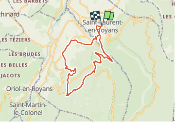

Length
16.3 km

Max alt
912 m

Uphill gradient
803 m
Km-Effort
27 km

Min alt
241 m

Downhill gradient
803 m
Boucle
Yes
Creation date :
2024-05-12 05:24:01.0
Updated on :
2024-05-12 09:28:43.212

FREE GPS app for hiking
 SityTrail
IGN / Geographical institutes
SityTrail Plus
The world is yours!
About
Trail of 16.3 km to be discovered at Auvergne-Rhône-Alpes, Drôme, Saint-Laurent-en-Royans. This trail is proposed by alinetpierre.
Description
Rando organisée à Saint Laurent en Royansr
Photos


Positioning
Country:
France
Region :
Auvergne-Rhône-Alpes
Department/Province :
Drôme
Municipality :
Saint-Laurent-en-Royans
Location:
Unknown
Start:(Dec)
Start:(UTM)
683227 ; 4988665 (31T) N.
Comments