


Confrecourt

tine60
User
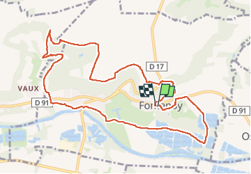

Length
11.4 km

Max alt
134 m

Uphill gradient
153 m
Km-Effort
13.4 km

Min alt
37 m

Downhill gradient
147 m
Boucle
Yes
Creation date :
2024-05-12 06:54:37.0
Updated on :
2024-05-12 09:33:05.595

FREE GPS app for hiking
 SityTrail
IGN / Geographical institutes
SityTrail Plus
The world is yours!
About
Trail of 11.4 km to be discovered at Hauts-de-France, Aisne, Fontenoy. This trail is proposed by tine60.
Positioning
Country:
France
Region :
Hauts-de-France
Department/Province :
Aisne
Municipality :
Fontenoy
Location:
Unknown
Start:(Dec)
Start:(UTM)
514451 ; 5472732 (31U) N.
Comments